
Nate Johnson
For all the fancy graphics and emphasis on engaging telegenic personalities, the value of a TV station’s weather report comes down to its accuracy in telling viewers what the weather is going to be over the next few days. Can they count on the station to know if it going to rain this weekend?
And, according to an independent TV forecasting rating service, the NBC O&Os do call it as well as any group in the nation.
Based on its comparison of forecasts in 90 markets for the year ending Feb. 28, WeatheRate declared that eight of the 11 NBC stations are the “most accurate” in their markets — WNBC New York, KNBC Los Angeles, WMAQ Chicago, WCAU Philadelphia, KNTV San Francisco, KXAS Dallas, WTVJ Miami and WVIT Hartford, Conn. The group’s other three stations were judged the second most accurate in their market.
The achievement is primarily that of the individual meteorologists in the markets, but it also reflects the group’s commitment to providing those weather pros with the best in forecasting tools and other support.
Overseeing weather for the NBC stations as well as for NBCU’s Telemundo stations is Director of Weather Operations Nate Johnson, who joined NBCU from Capitol Broadcasting in Raleigh, N.C., in November 2017.
In this interview with TVNewsCheck Editor Harry A. Jessell, he defines his role as promulgating best practices and providing a clearinghouse for good ideas from across the group. His job is also strategic — “figuring out what weather is going to be in five, 10, 15 years and how we can best position ourselves to move in that direction.”
Johnson also talks about what goes into the making of the group’s highly-rated forecasts and how to make the most of what comes out with smart and relevant storytelling. “What I’m encouraging our meteorologists to do is really take a step back from the meteorology and address what do the viewers really need out of there and what is the important today.”
An edited transcript.
At a TVNewsCheck conference last fall, NBCU Television Stations President Valari Staab said that the group’s forecasting prowess comes from its own weather modeling. Can you elaborate?
What we are trying to do is leverage all of the different modeling products — the American, the European, the Canadian and so forth — and pull them in under one umbrella and evaluating them on a day-by-day basis to see which ones are performing well, which ones are performing poorly. Then we can weigh all of that in an automated fashion and in a manual fashion to determine what our final NBC forecasts might be for a given spot at a given time.
This is really the way that meteorology is moving — toward an ensemble approach. The notion is that no single model is going to be right all the time. The best meteorologists use a toolbox approach and say, well, today is a time where the American model might do well or tomorrow the situation with a European might do better, that sort of thing.
So NBC’s model is actually a composite of all these other ones?
To say “composite” may be a little oversimplified. But the general idea is we are taking the best of all of these models and combining them into a single data source for our meteorologists to use. They are obviously free to look at the individual models to see how all this comes together.
I know that NBC has made a heavy investment in local radar. Are you using the radar data to enhance the forecasts?
No, we are not at that point. Radar data is really most useful in the moment — in the next five minutes to an hour or two. We’re using that in sort of a real-time mode to determine where, let’s say, a thunderstorm may be going, where the rain, sleet, snow transition may be taking place.
Do you have radar everywhere now?
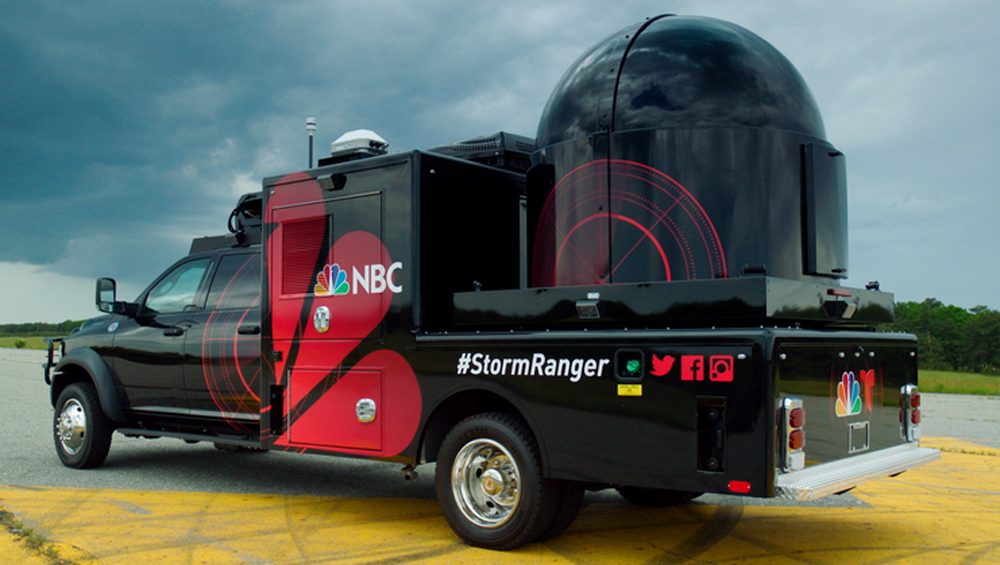
 We have 13 radars, including seven fixed installations. They’re in Southern California and one each in New York, Chicago, Dallas and Miami. We also have our six mobile Storm Ranger units, which live primarily in certain spots, but can go anywhere that we need them to go. [NBC claims that its weather radar network is the fourth largest in the country.]
When your meteorologists present a forecast, do they generally talk about how the various models may differ?
So if the European and the American are arguing that it’s either going to be four to six inches or six to eight inches, I am not going to spend a lot of time on that particular angle because it doesn’t really affect what the viewers are going to see in the moment.
We are really trying to focus on, how is this going to affect your life? How do you need to change your normal routine tomorrow or this weekend or next week? What do you need to be prepared for? What sorts of things do you need to be thinking about?
And I would liken this to going to a doctor’s office. You go and they draw blood and they take other samples and the tests produce pages of results. What I count on my doctor to do is to sift through all of that for me and then highlight the things that I need to be aware of. You know, cholesterol may, for example, be a little too high or the blood pressure may be too high. The job is to elevate the things that I need to know and then just filter out the rest. That is what we really hoping to empower our meteorologists to do.
Now, in some cases, there are differences. The hurricane season is a really good example of this. The American says it’s going to veer into Florida; the European says it is going to veer out to sea. Those sorts of situations do happen.
If we think that both of those solutions are legitimate and have some credibility to them, then we will present both, but it is always with a focus on, OK, what are you going to do with that information. I can’t just say here is a bunch of models, go have fun. That’s not very helpful.
What I can do is say here are the scenarios that we need to be ready for and here are the data that support each one of these scenarios and then here is what you need to do with the information whether it is making evacuation plans or maybe just sitting tight.
Give me a good example of how you try to make the forecast relevant.
A couple of months ago, we had a really dry stretch in Texas. But over the course of about a week they had a fairly significant amount of rain across the entire area with some areas getting a little more than others.
And so what our Telemundo chief meteorologist in that market did wasn’t to answer for the viewer how much rain did I get. It was, how long do I not have to water now that I have had all this rain? We have been watering all through this dry stretch, when do I have to start watering again?
What about augmented reality? Are you investing is those sorts of elaborate graphics?
We think there is a place for them. The key is, how can we use this particular tool to enhance our storytelling. If it helps us explain what is going on in a way that a flat graphic can’t or that a live shot can’t or what have you, then we will look to use it.
What we don’t want to do is simply use augmented reality set pieces and things like that. If it’s not the right tool for the job, then we don’t expect to use it. We will find another way to get the point across.
Operationally, how does this work? I know that you are based in Raleigh. Do you have a central weather desk there?
Each of our stations operates independently, but we do have some centralized functions. We have our art house, our centralized graphics facility in Dallas, but each station retains capability of building graphics on their own. The meteorologist in some cases, do their own. In Dallas, Nestor Flecha [of Telemundo KXTX] is a very capable graphic artist in addition to being a degreed meteorologist with certification.
So we are relying on assets all across our group to make those decisions and to really contribute to it. The centralized graphics hub is going to contribute some things and our local stations will contribute things.
Part of my role in this is to make sure that the left hand is knowing what the right hand is doing and that, if we built something really snazzy in New York that we think is going to also work for Chicago, then we will make sure that Chicago is aware of it.
Do you have a big computer down in Raleigh where you collect and crunch all the weather data?
I don’t in Raleigh. We have our modeling infrastructure. We are pulling in all of the data from NOAA and European modeling groups and then running it and putting in all of our corporate networks. So I have access to it pretty much anywhere I go and I do have one of our the graphics systems that we use, the WSI, that I use to help proof things on the air or that may go on the air and to make sure that the data quality is good.


Comments (0)